Your Fields, Assessed Every Morning Before You Start Your Day
Xsupra runs a complete risk analysis on every one of your fields, every single day — before you have had your morning coffee.
What We Collect, What You Get
Every day, the Xsupra system automatically gathers the latest data for each of your subscribed fields:
Weather
The last 30 days of history plus a 5-day forecast, down to hourly detail at your field's exact coordinates.
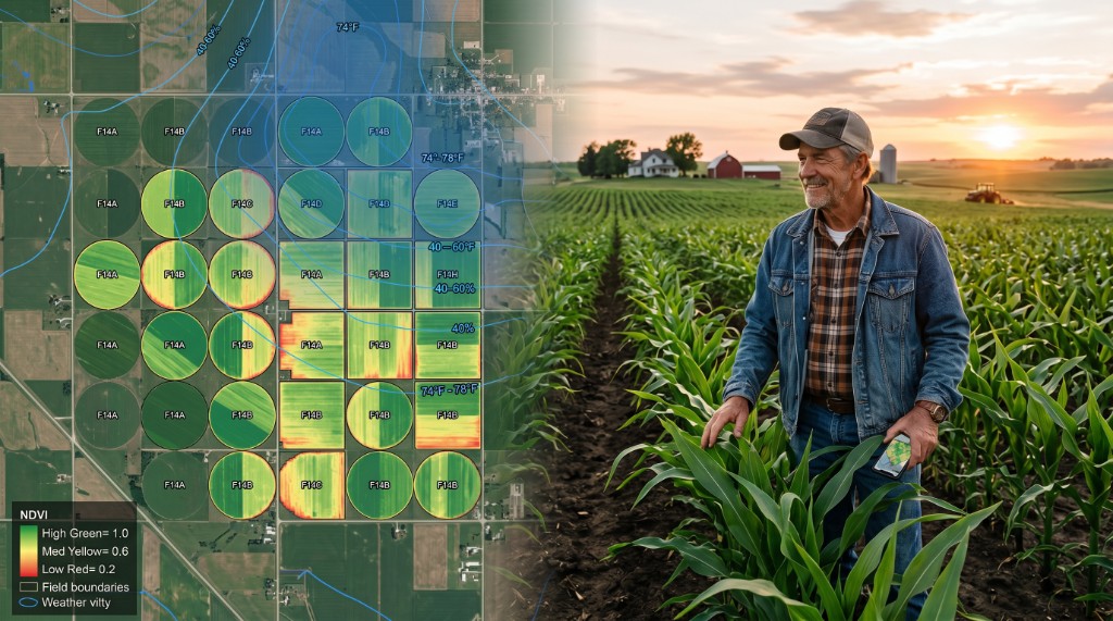
Satellite imagery
Vegetation health indices showing how your crops are actually developing across different parts of your field.
Soil conditions
Moisture levels, terrain characteristics, and soil composition.
Your farm data
Crop type, growth stage, fertilization records, plant protection documentation.
From this raw data, we calculate hundreds of specific metrics — precipitation windows, temperature trends, frost risk indicators, vegetation trajectories, soil moisture states, and more.
Alerts That Matter, Not Noise
The Xsupra rule engine evaluates your fields against a comprehensive catalog of agricultural risks, organized into clear categories:
Risk alerts
Immediate threats like drought stress, waterlogging risk, frost danger, or pest pressure windows. You see what is happening and why it matters.
Optimization opportunities
Ideal application windows, nutrient timing, irrigation considerations. Not generic advice — calculations based on your field's actual conditions right now.
Regulatory compliance
Automated checks against local regulations so you never accidentally violate a restricted application period or environmental protection requirement.
Every alert comes with a severity level and a plain-language explanation. Your fields are scored on an overall risk scale so you can see at a glance which fields need attention today.
Zone-Level Precision
Your field is not uniform
The northern slope drains differently than the southern flat. The east side gets morning shade. Soil composition varies across the parcel.
Xsupra divides your fields into zones based on satellite-derived vegetation patterns and evaluates each zone independently.
"The northern section of your wheat field is showing early drought stress" — while the rest is perfectly healthy.
This precision helps you target your response exactly where it is needed — saving time, inputs, and money.
Compliance Without the Headache
Regulations change. New environmental zones are designated. Application windows shift. Keeping track of all of this across multiple fields and crops is a full-time job.
- Nutrient application ban periods
- Buffer zone restrictions
- Crop-specific protection rules
- Environmental protection requirements
Xsupra checks your fields against country-specific and region-specific regulatory requirements daily. As new regulations are introduced, the system encodes them automatically — your compliance checks stay current without you lifting a finger.
Your Assessment History Grows With You
Every assessment is stored. Over weeks, months, and seasons, you build a complete picture of how your fields perform:
- 1Where risks recur season after season
- 2Which zones consistently underperform
- 3How weather patterns affect your specific parcels
This is the kind of intelligence that used to require years of personal experience on a single farm. Xsupra gives it to you from day one, and it gets richer every day.
Xsupra: your fields, analyzed. Every day. Every zone. Every risk that matters.

Try it now
Nézze meg, hogyan működik az Xsupra az Ön tábláin. Ingyenesen indítható.
Ingyenesen indítható, bankkártya nélkül