Product
Everything your farm needs. One platform.
Soil maps, daily monitoring, application maps, AI advisory, and digital field records — accessible on your phone and your desk.
Free to get started — no credit card required
Web Dashboard & Mobile App
Blijf op de hoogte van uw percelen met dagelijkse monitoring, nauwkeurige bodemkaarten en duidelijke aanbevelingen. Ontdek problemen vroeg, optimaliseer inputs en houd uw gegevens op orde — alles op één plek.
Precision Soil Maps
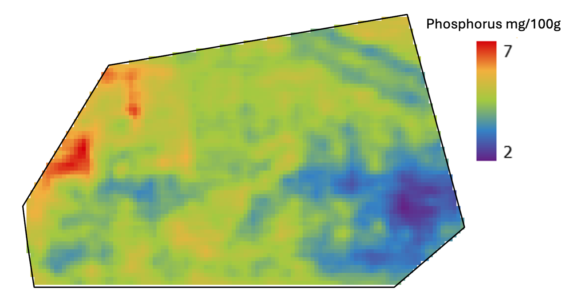
Modeled, not interpolated
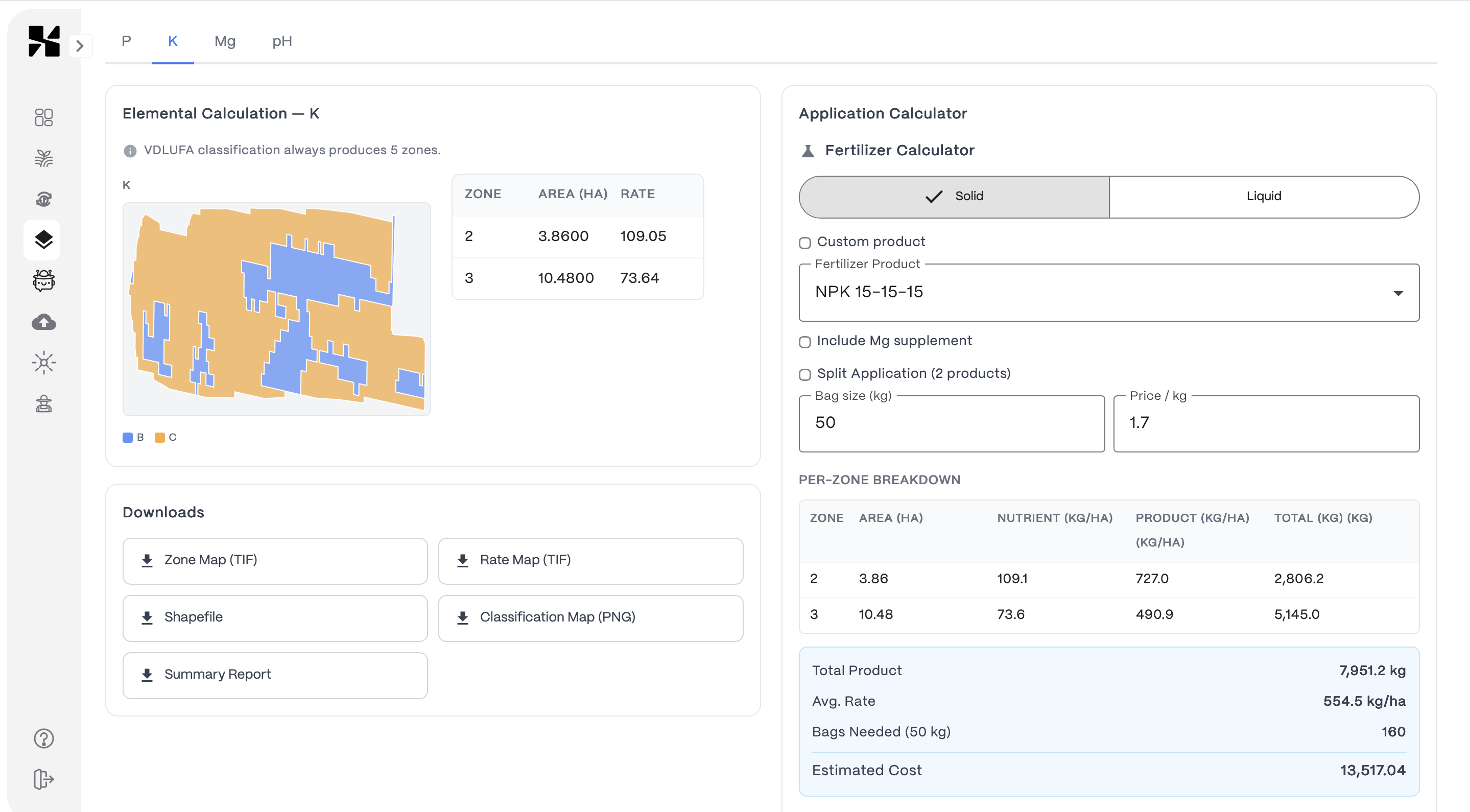
Application Maps
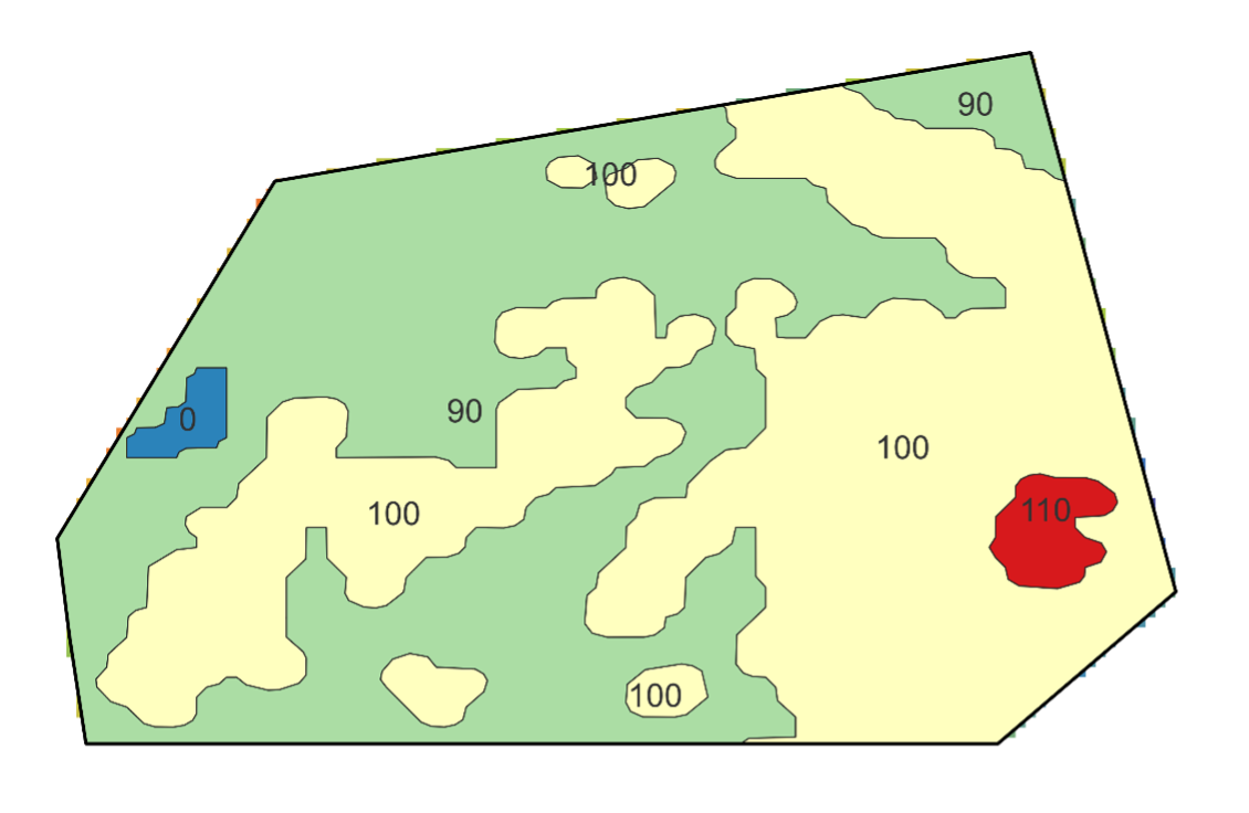
Zone-based rates — export ready for your terminal
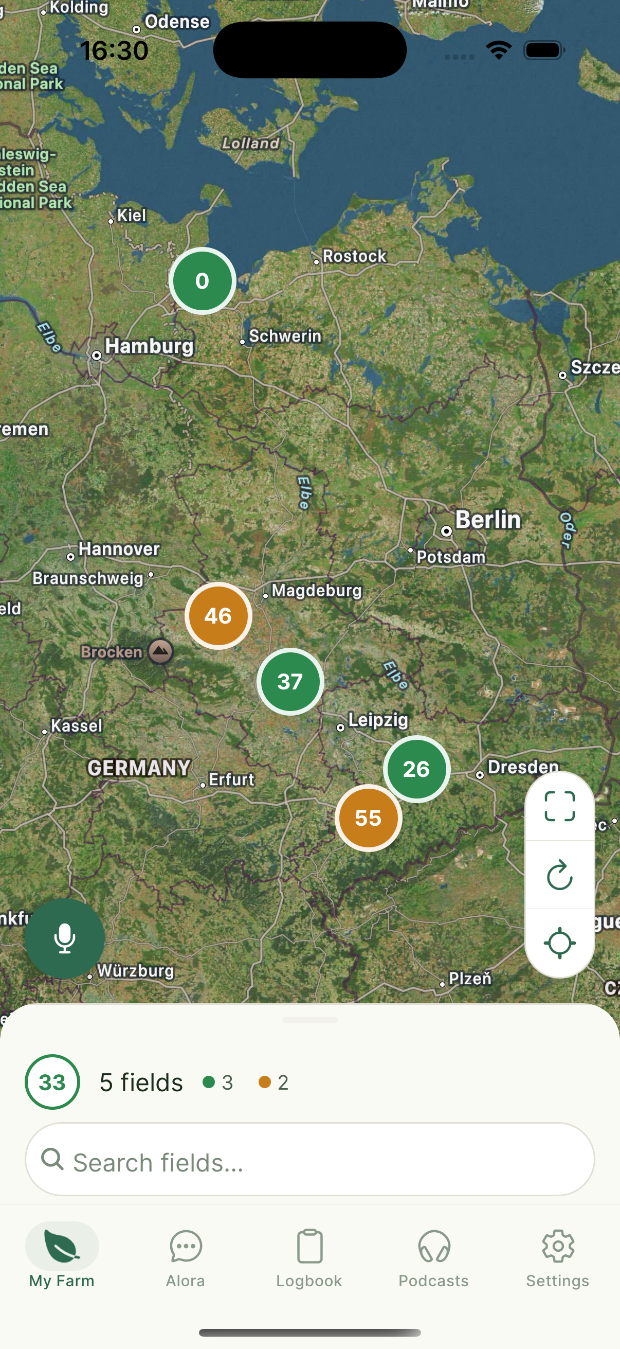
Farm Overview
All fields on one map
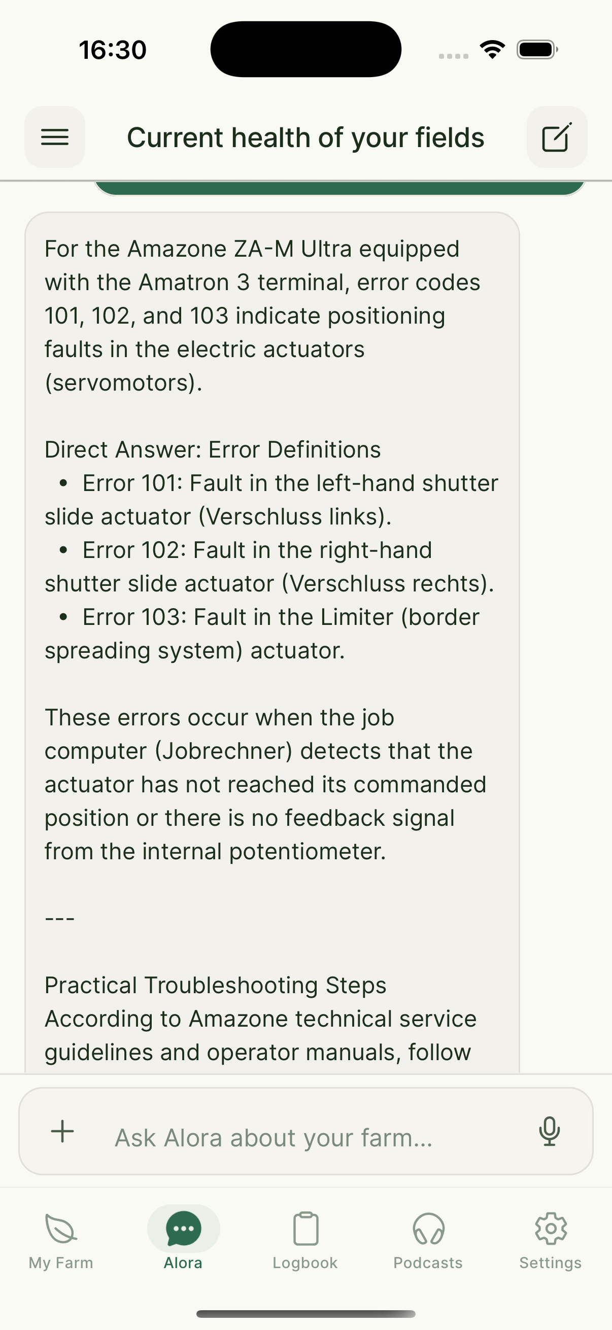
AI Assistant
Ask Alora anything
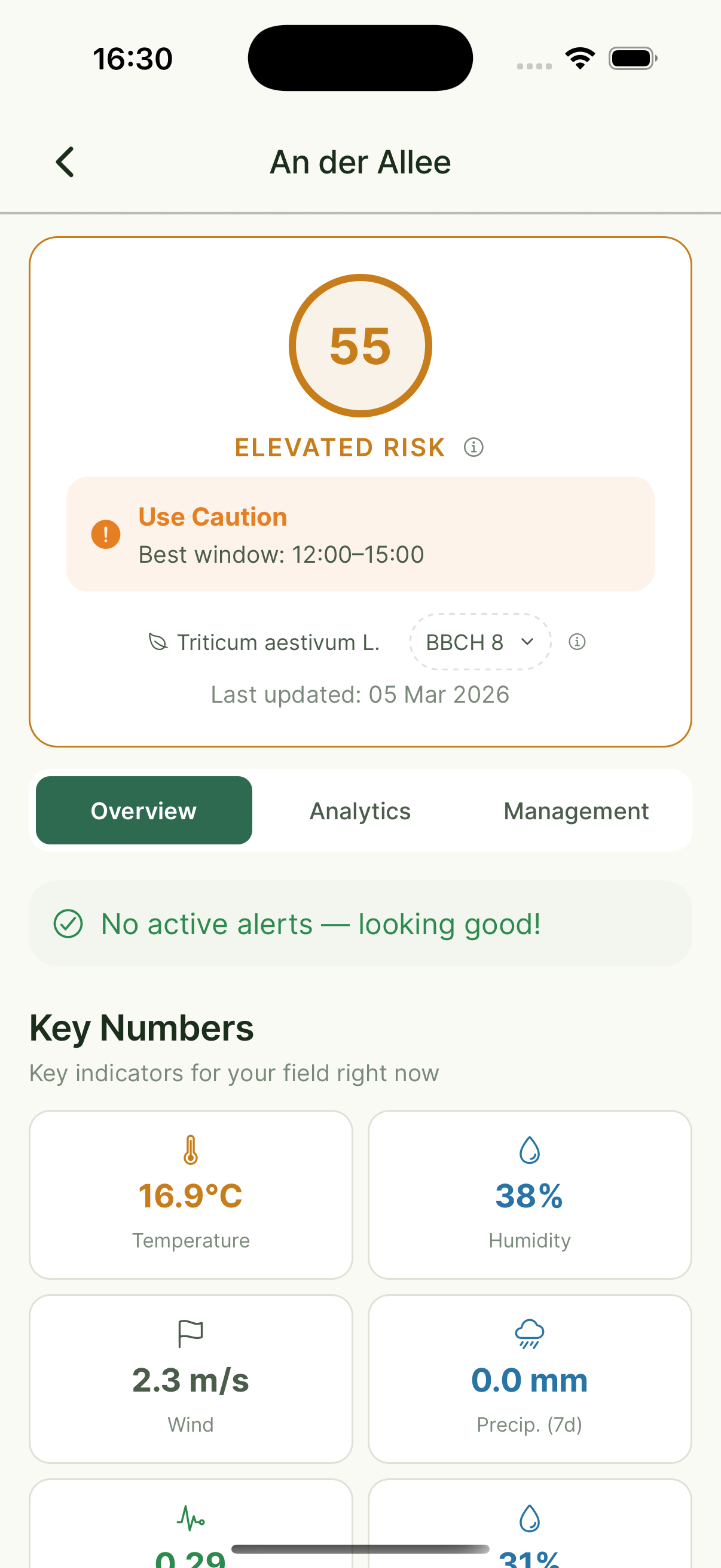
Field Detail
Risk scores & weather

Daily Podcast
Personalized field updates
Wat Xsupra voor u doet
Praktische tools gebouwd rond echte problemen die boeren dagelijks ervaren.
Bodemmonsters & bodemeigenschappenkaarten
Monster waar uw perceel daadwerkelijk varieert — niet op een star raster. Onze modellen produceren doorlopende bodemeigenschappenkaarten die echte variatie vastleggen, niet gladgestreken gemiddelden.
Meer informatieApplicatiekaarten (VRA)
Zet nauwkeurige bodemkaarten om in bemestingszones die uw kunstmeststrooier kan gebruiken. Elke zone krijgt de dosis die het daadwerkelijk nodig heeft.
Meer informatieMonitoring & meldingen
Dagelijkse satellietcontroles op elk perceel: vegetatieveranderingen, spuitomstandigheden, bodemvocht en nalevingsdeadlines.
Meer informatieAlora — uw AI-boerderijassistent
Vraag Alora van alles via spraak of tekst. Ze kent uw percelen, logt uw activiteiten, detecteert ziektes uit foto's en geeft u een dagelijkse audiobriefing.
Meer informatieSubsidie- en nalevingsondersteuning
Veldactiviteiten automatisch gelogd. Wanneer het tijd is voor uw aanvraag, vraag Alora wat er is gebeurd — en exporteer alles wat u nodig heeft.
Meer informatieDigitale teeltregistratie
Uw digitale perceelsregistratie. Alle activiteiten per perceel vastgelegd, overzichtelijk en exporteerbaar — geen papieren mappen of spreadsheets meer.
Meer informatieProfessionele rapporten — voor uw adviseur, auditor of autoriteit.
Xsupra genereert automatisch een uitgebreid Farm Report als PDF uit uw veldgegevens. Zone-analyse, activiteitenlogs, risicobeoordelingen, weersgegevens en compliance-notities — alles in één document. Exporteer en deel met één klik.
What Farmers Say
“Alora's expert answers to our questions worked really well and saved us 2–3 hours of research time per week during busy periods.”
Sandro Stutzer
Landprodukte Tangerland eG
“We vergeleken de monsternemingsresultaten van Xsupra met onze interne aanpak: het 10 x 10 m raster is aanzienlijk nauwkeuriger en preciezer. Met de bodemkaarten besparen we tot 50% op meststof en ongeveer 6 uur per week op veldinspecties. De service en onboarding waren zeer toegewijd en professioneel — het is een genoegen om mee samen te werken.”
Mathias Dippe
Agrar Dippe GmbH & Co. KG — 880 ha, 14 gewassen, Saksen-Anhalt
“AI-based software solutions like Xsupra, tailored to individual fields and management measures, not only conserve farm resources but also contribute to greater sustainability in a broader societal context.”
Katrin Kraft
Owner, Aeikens & Kraft GbR, Agricultural Consultant
Beschikbaar op alle apparaten
Uw percelen, uw data — toegankelijk vanaf uw telefoon of bureau. Geen gedoe meer met losse apps en spreadsheets.
Get started in three steps
Create your free account
Sign up at farm.xsupra.io — no credit card needed.
Add your fields
Draw your fields on the map or import them. We start monitoring immediately.
Get your first insights
Vegetation maps, soil data, and your first Alora briefing — within 24 hours.
“Als u waardevolle bedrijfstijd wilt besparen en sneller beslissingen wilt nemen, gebruik dan Xsupra.”
Mathias Dippe
Agrar Dippe GmbH & Co. KG — 880 ha, 14 gewassen
Frequently Asked Questions
Do I need technical knowledge to use Xsupra?
How does the soil mapping work?
What crops and regions does Xsupra support?
Can I export application maps to my tractor terminal?
What does the AI assistant Alora actually do?
How much does Xsupra cost?
Does Xsupra's soil sampling method meet German legal requirements?
Klaar om te zien hoe het werkt op uw percelen?
Plan een gratis gesprek. We bekijken uw situatie samen — geen verkooppraatje, gewoon een eerlijk gesprek over of Xsupra bij u past.
Free to get started — no credit card required