Produkt
Everything your farm needs. One platform.
Soil maps, daily monitoring, application maps, AI advisory, and digital field records — accessible on your phone and your desk.
Free to get started — no credit card required
Web Dashboard & Mobile App
Håll koll på dina fält med daglig övervakning, exakta jordkartor och tydliga rekommendationer. Upptäck problem tidigt, optimera insatser och håll dina anteckningar i ordning — allt på ett ställe.
Precision Soil Maps
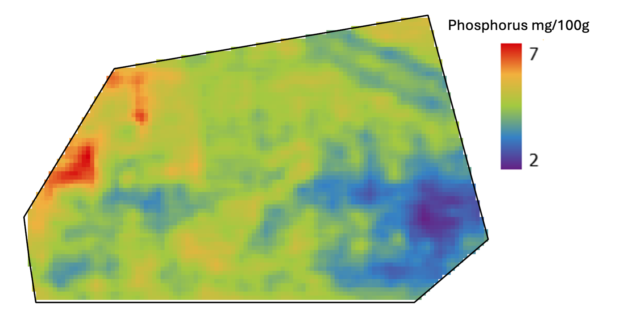
Modeled, not interpolated
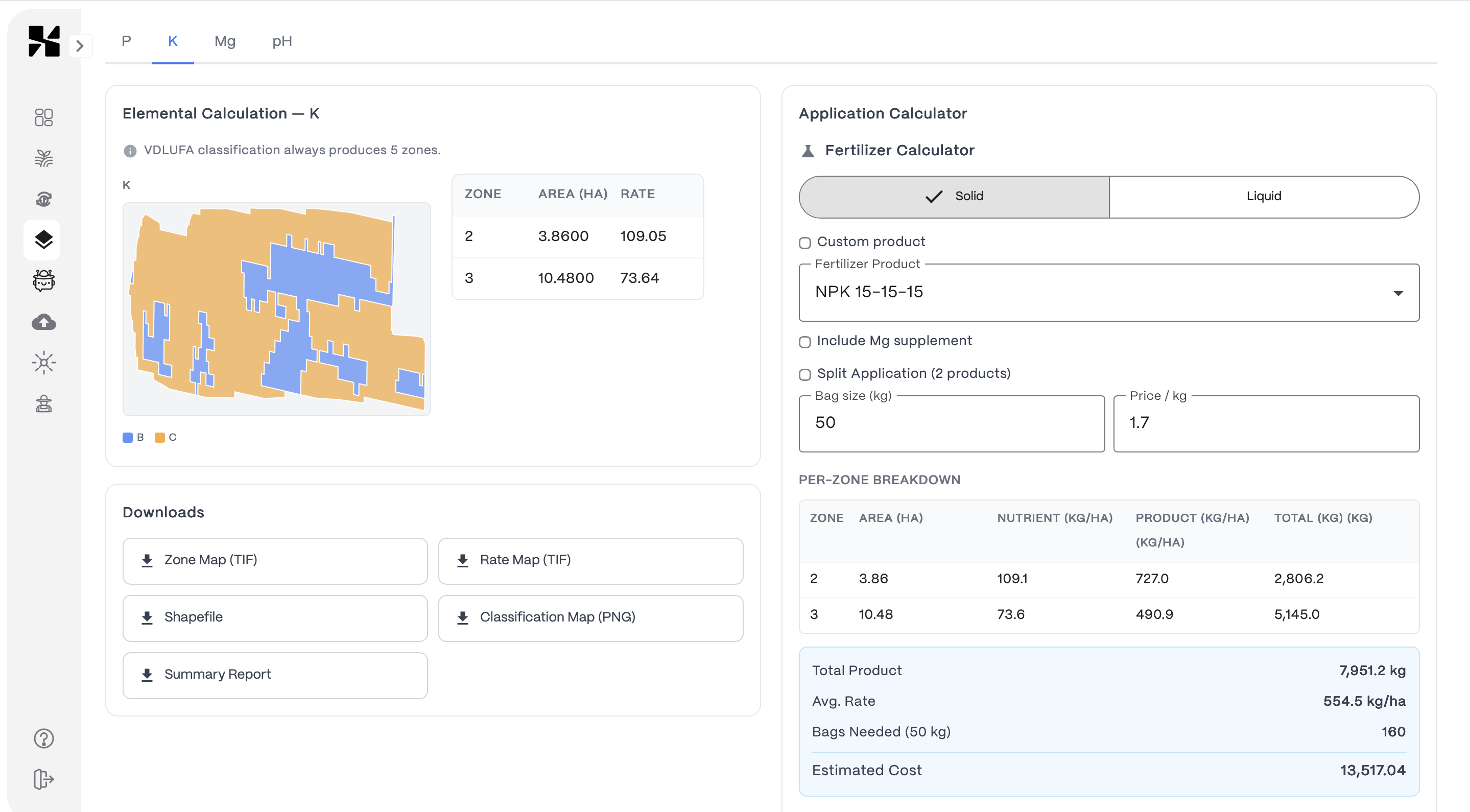
Application Maps
Zone-based rates — export ready for your terminal
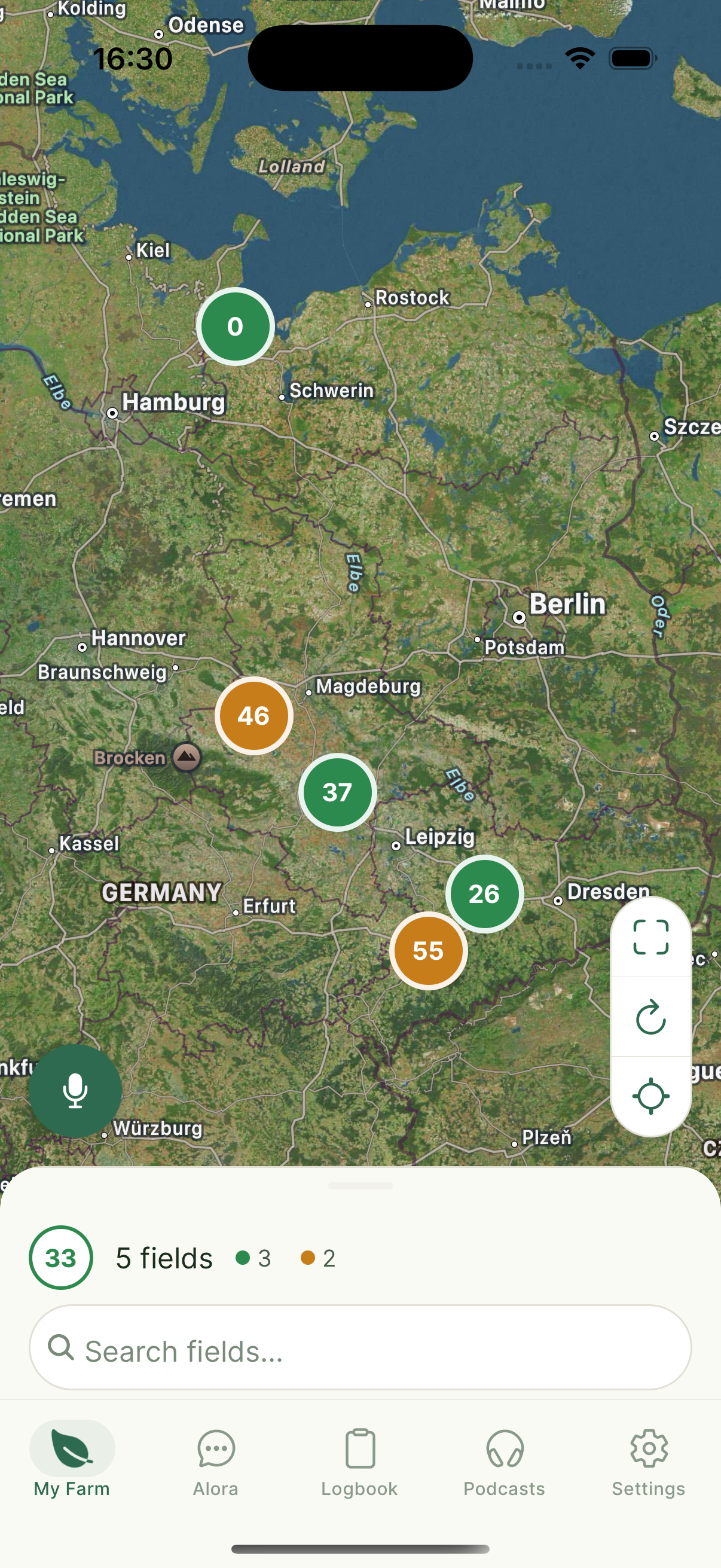
Farm Overview
All fields on one map
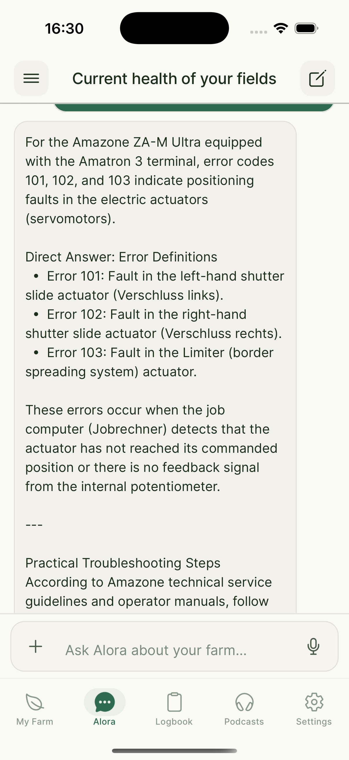
AI Assistant
Ask Alora anything
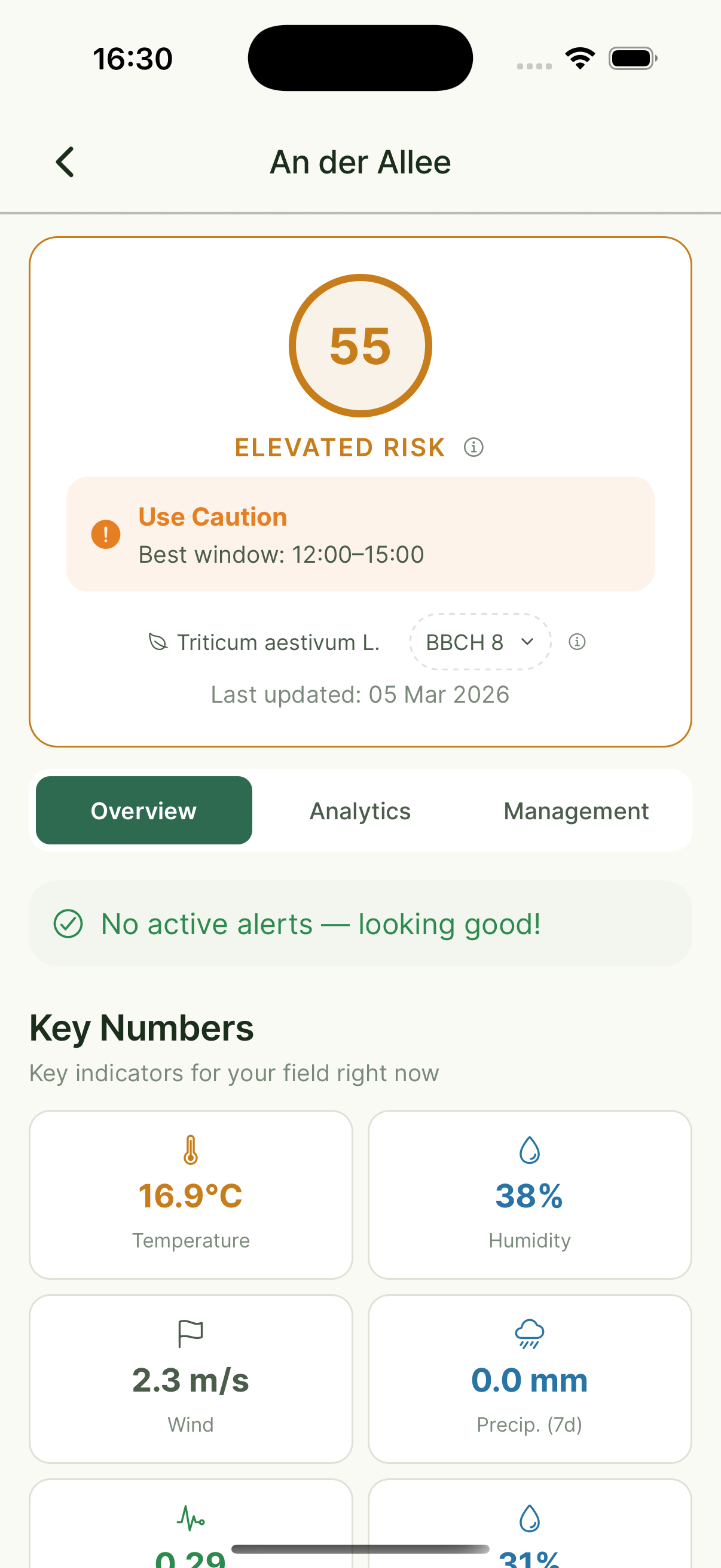
Field Detail
Risk scores & weather

Daily Podcast
Personalized field updates
Vad Xsupra gör för dig
Praktiska verktyg byggda kring verkliga problem lantbrukare möter varje dag.
Jordprovtagning & markkartering
Provta där skiftet verkligen varierar — inte på ett styvt rutnät. Våra modeller skapar kontinuerliga markkartor som fångar verklig variation, inte utjämnade medelvärden.
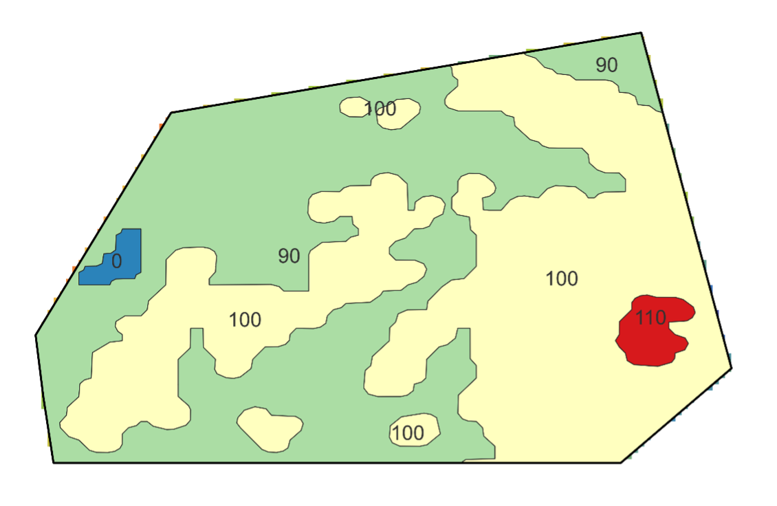
Läs merTilldelningskartor (VRA)
Omvandla exakta markkartor till gödslingszoner din gödselspridare kan använda. Varje zon får den giva som faktiskt behövs.
Läs merÖvervakning & aviseringar
Dagliga satellitkontroller på varje skifte: vegetationsförändringar, sprutningsförhållanden, markfukt och regelefterlevnad.
Läs merAlora — din AI-jordbruksassistent
Fråga Alora vad som helst via röst eller text. Hon känner dina fält, loggar dina aktiviteter, upptäcker sjukdomar från foton och ger dig en daglig ljudgenomgång.
Läs merEU-stöd & regelefterlevnad
Fältaktiviteter loggas automatiskt. När det är dags för SAM-ansökan, fråga Alora vad som hände — och exportera allt du behöver.
Läs merDigital växtodlingsjournal
Din förenklade växtodlingsjournal. Alla fältaktiviteter inspelade, organiserade och exporterbara — inga fler pappersmappar eller kalkylblad.
Läs merProfessionella rapporter — för din konsult, revisor eller myndighet.
Xsupra genererar automatiskt en omfattande Farm Report som PDF från dina fältdata. Zonanalys, aktivitetsloggar, riskbedömningar, väderdata och efterlevnadsanteckningar — allt i ett dokument. Exportera och dela med ett klick.
What Farmers Say
“Alora's expert answers to our questions worked really well and saved us 2–3 hours of research time per week during busy periods.”
Sandro Stutzer
Landprodukte Tangerland eG
“Vi jämförde Xsupras provtagningsresultat med vårt interna tillvägagångssätt: 10 x 10 m-rutnätet är avsevärt mer exakt och precist. Med jordkartorna sparar vi upp till 50% på gödning och cirka 6 timmar per vecka på fältinspektioner. Servicen och onboardingen var mycket engagerade och professionella — det är ett nöje att arbeta med dem.”
Mathias Dippe
Agrar Dippe GmbH & Co. KG — 880 ha, 14 grödor, Sachsen-Anhalt
“AI-based software solutions like Xsupra, tailored to individual fields and management measures, not only conserve farm resources but also contribute to greater sustainability in a broader societal context.”
Katrin Kraft
Owner, Aeikens & Kraft GbR, Agricultural Consultant
Tillgänglig på alla enheter
Dina fält, din data — tillgänglig från din telefon eller ditt skrivbord. Ingen mer jonglering med separata appar och kalkylblad.
Get started in three steps
Create your free account
Sign up at farm.xsupra.io — no credit card needed.
Add your fields
Draw your fields on the map or import them. We start monitoring immediately.
Get your first insights
Vegetation maps, soil data, and your first Alora briefing — within 24 hours.
“Om du vill spara värdefull affärstid och fatta snabbare beslut, använd Xsupra.”
Mathias Dippe
Agrar Dippe GmbH & Co. KG — 880 ha, 14 grödor
Frequently Asked Questions
Do I need technical knowledge to use Xsupra?
How does the soil mapping work?
What crops and regions does Xsupra support?
Can I export application maps to my tractor terminal?
What does the AI assistant Alora actually do?
How much does Xsupra cost?
Does Xsupra's soil sampling method meet German legal requirements?
Redo att se hur det fungerar på dina fält?
Boka ett gratis samtal. Vi tittar på din situation tillsammans — ingen försäljning, bara ett ärligt samtal om Xsupra passar.
Free to get started — no credit card required