Product
Everything your farm needs. One platform.
Soil maps, daily monitoring, application maps, AI advisory, and digital field records — accessible on your phone and your desk.
Free to get started — no credit card required
Web Dashboard & Mobile App
Stay on top of your fields with daily monitoring powered by a proprietary risk model (1,200+ checks per field and zone), accurate soil maps, and clear recommendations. Catch problems early, optimize inputs, and keep your records straight — all in one place.
Precision Soil Maps
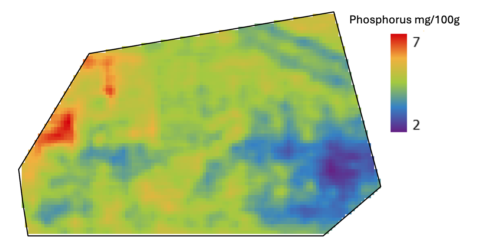
Modeled, not interpolated
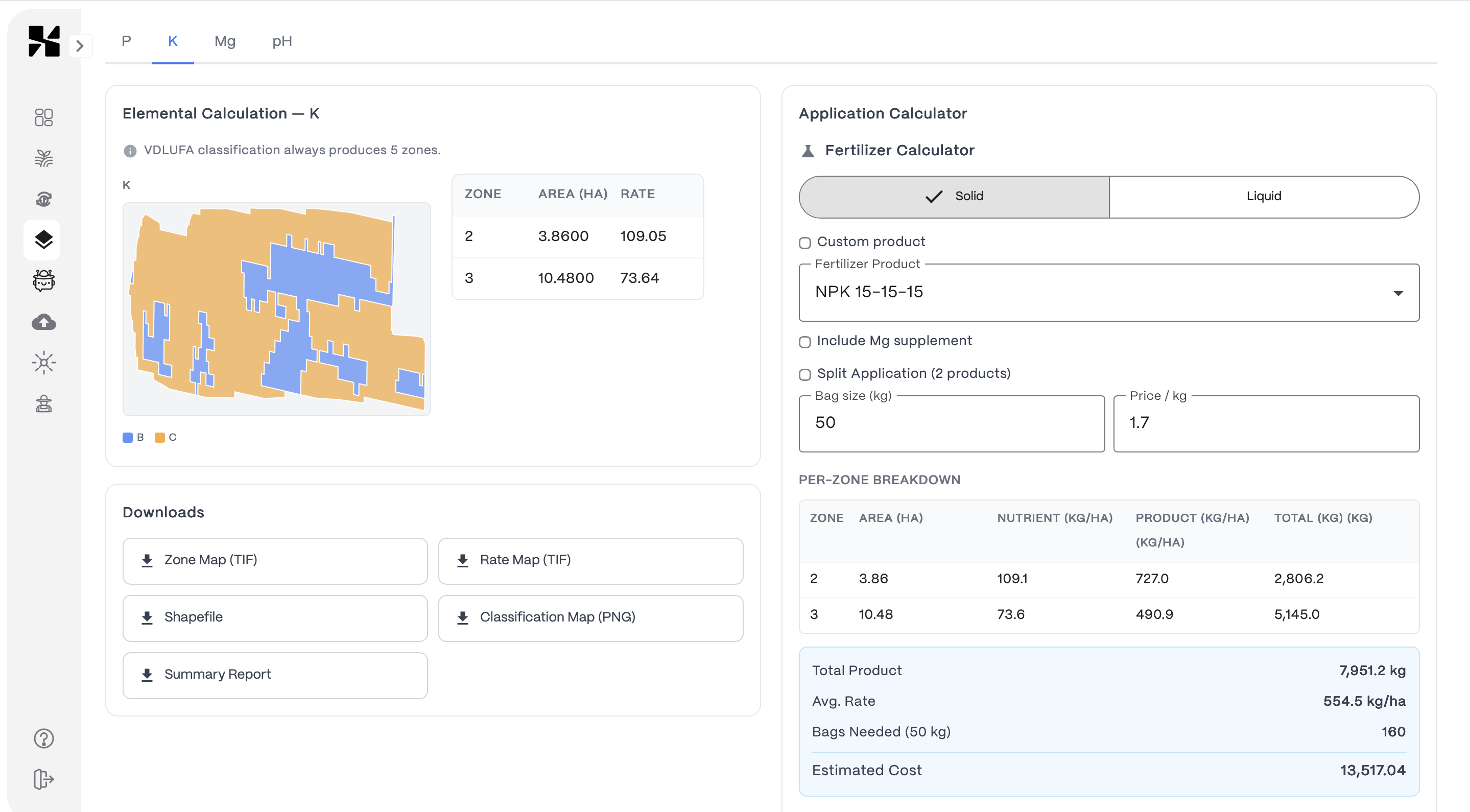
Application Maps
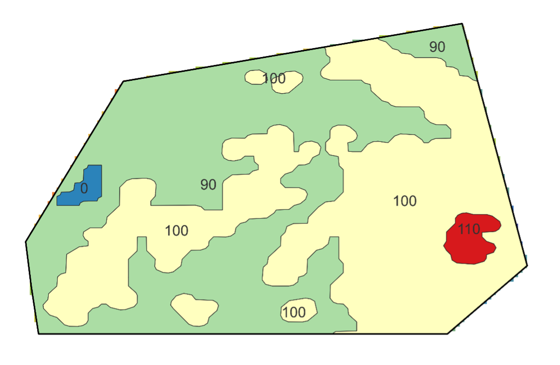
Zone-based rates — export ready for your terminal
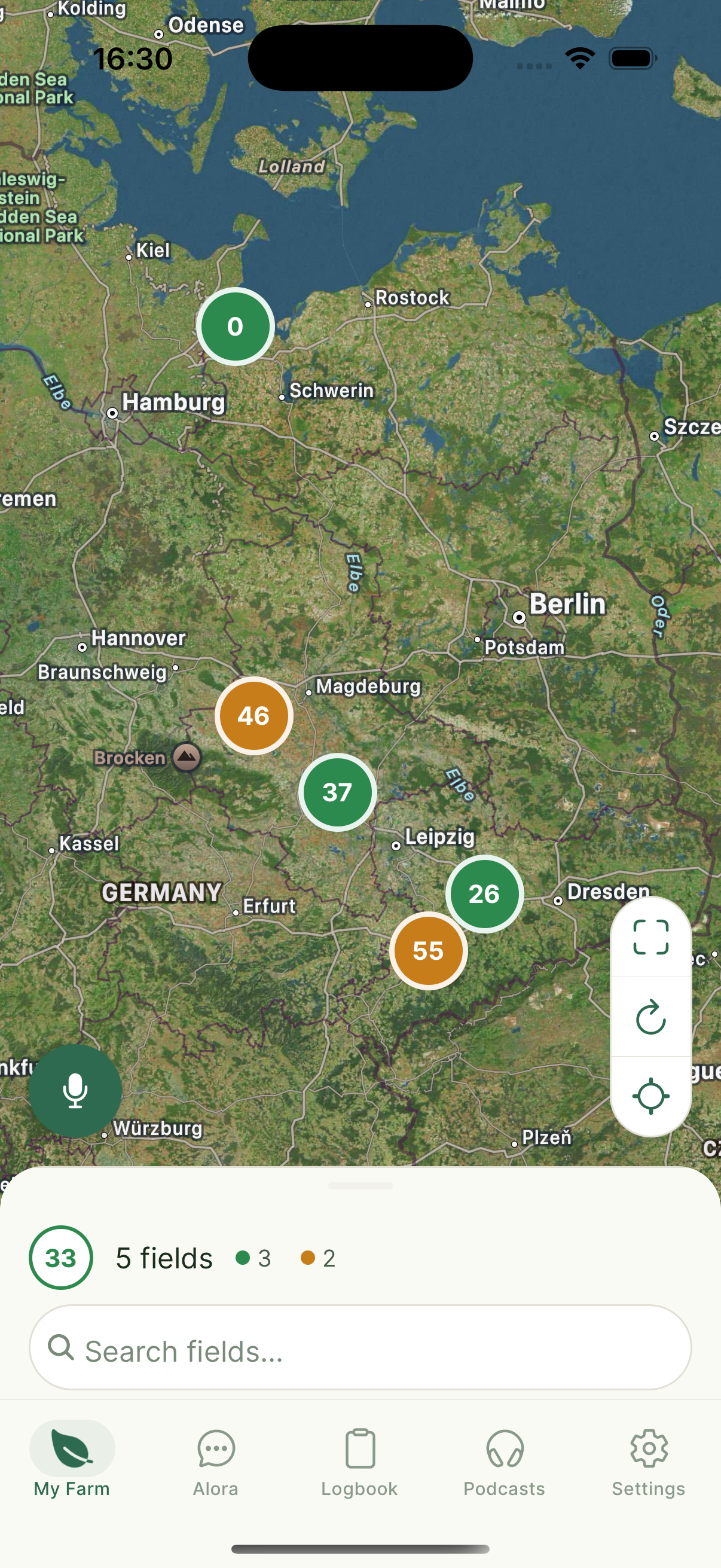
Farm Overview
All fields on one map
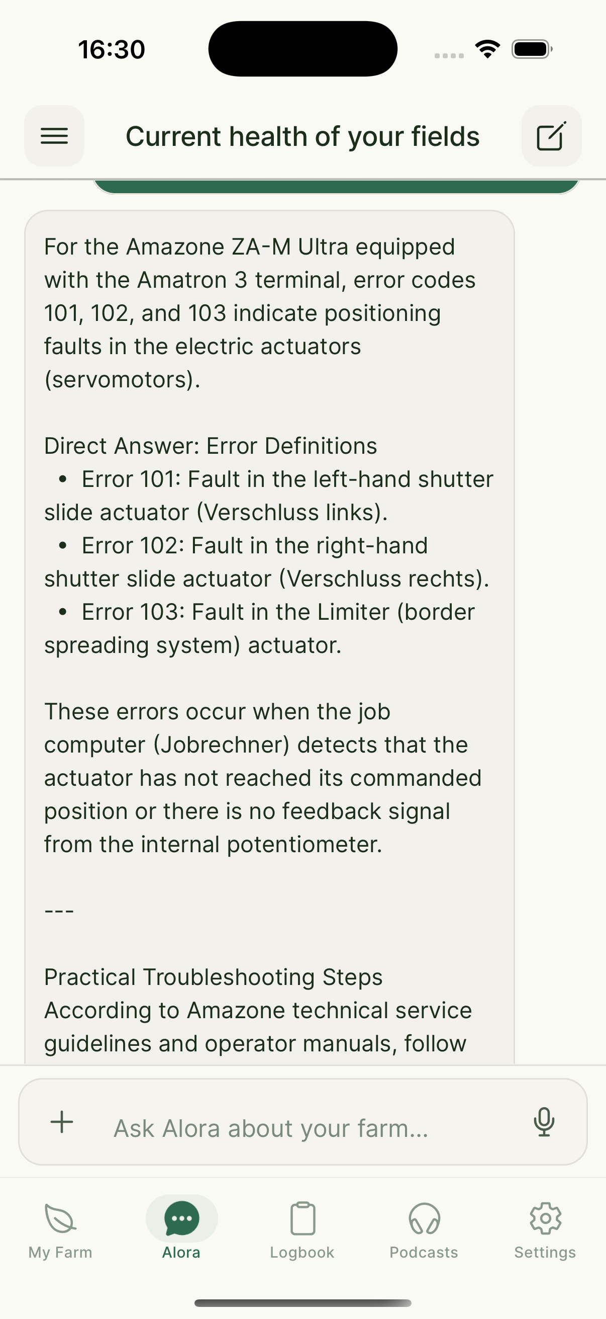
AI Assistant
Ask Alora anything
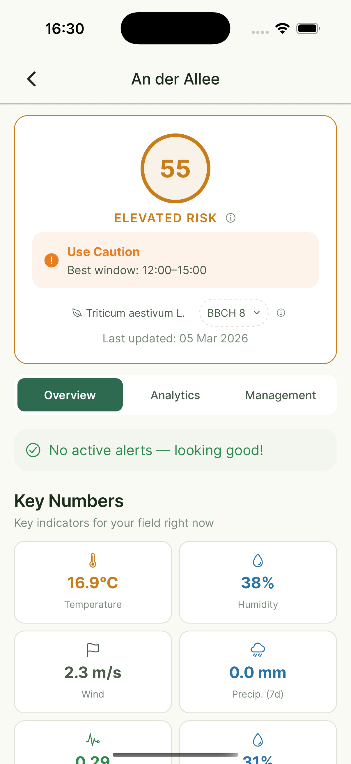
Field Detail
Risk model scores & weather

Daily Podcast
Personalized field updates
What Xsupra does for you
Practical tools built around real problems farmers face every day.
Soil Sampling & Soil Property Maps
Sample where your field actually varies — not on a rigid grid. Our models produce continuous soil property maps that capture real variation, not smoothed-out averages.
Learn MoreApplication Maps (VRA)
Turn accurate soil maps into fertilization zones your spreader can use. Each zone gets the rate it actually needs.
Learn MoreMonitoring & Alerts
Daily satellite checks and a proprietary risk model on every field and zone — 1,200+ factors including vegetation, compliance, and disease-related signals. Spray windows and deadline reminders included.
Learn MoreAlora — Your AI Farm Assistant
Ask Alora anything by voice or text. She knows your fields, logs your activities, detects diseases from photos, and gives you a daily audio briefing.
Learn MoreSubsidy & Compliance Support
Field activities logged automatically. When it's time for your application, ask Alora what happened — and export everything you need.
Learn MoreDigital Field Records
Your simplified digital Ackerschlagkartei. All field activities recorded, organized, and exportable — no more paper binders or spreadsheets.
Learn MoreProfessional reports — for your consultant, auditor, or authority.
Xsupra automatically generates a comprehensive Farm Report as PDF from your field data. Zone analysis, activity logs, risk assessments, weather data, and compliance notes — all in one document. Export and share with one click.
What Farmers Say
“Alora's expert answers to our questions worked really well and saved us 2–3 hours of research time per week during busy periods.”
Sandro Stutzer
Landprodukte Tangerland eG
“We compared Xsupra's sampling results with our in-house approach: the 10 x 10 m grid is significantly more accurate and precise. With the soil maps, we save up to 50% on fertilizer and about 6 hours per week on field inspections. The service and onboarding were very dedicated and professional — it's a pleasure to work with.”
Mathias Dippe
Agrar Dippe GmbH & Co. KG — 880 ha, 14 crops, Saxony-Anhalt
“AI-based software solutions like Xsupra, tailored to individual fields and management measures, not only conserve farm resources but also contribute to greater sustainability in a broader societal context.”
Katrin Kraft
Owner, Aeikens & Kraft GbR, Agricultural Consultant
Available on all devices
Your fields, your data — accessible from your phone or your desk. No more juggling separate apps and spreadsheets.
Get started in three steps
Create your free account
Sign up at farm.xsupra.io — no credit card needed.
Add your fields
Draw your fields on the map or import them. We start monitoring immediately.
Get your first insights
Vegetation maps, soil data, and your first Alora briefing — within 24 hours.
“If you want to save valuable business time and make faster decisions, use Xsupra.”
Mathias Dippe
Agrar Dippe GmbH & Co. KG — 880 ha, 14 crops
Frequently Asked Questions
Do I need technical knowledge to use Xsupra?
How does the soil mapping work?
What crops and regions does Xsupra support?
Can I export application maps to my tractor terminal?
What does the AI assistant Alora actually do?
How much does Xsupra cost?
Does Xsupra's soil sampling method meet German legal requirements?
Ready to see how it works on your fields?
Book a free call. We'll look at your situation together — no sales pitch, just an honest conversation about whether Xsupra fits.
Free to get started — no credit card required