Mapping soil properties from space: how Xsupra combines Europe's largest soil survey with AlphaEarth
How we estimate continuous soil maps from satellite data and 7,000+ lab samples — without collecting a single sample in the field.
The problem with knowing your soil
Soil is the foundation of every farming decision — what to plant, how much to fertilize, where to apply lime, and how to manage variability within a field. Yet our knowledge of soil remains surprisingly coarse. The conventional way to characterize a field is to collect physical samples and send them to a laboratory. This is accurate, but it is also slow, costly, and inevitably sparse as a handful of samples are used to represent hectares of land that are rarely uniform. The result is a gap between how variable soil actually is and how much of that variability we can afford to measure. At Xsupra, we are developing an approach to close that gap by estimating soil properties continuously across a field, without collecting a single sample in the field itself.
Two datasets, combined
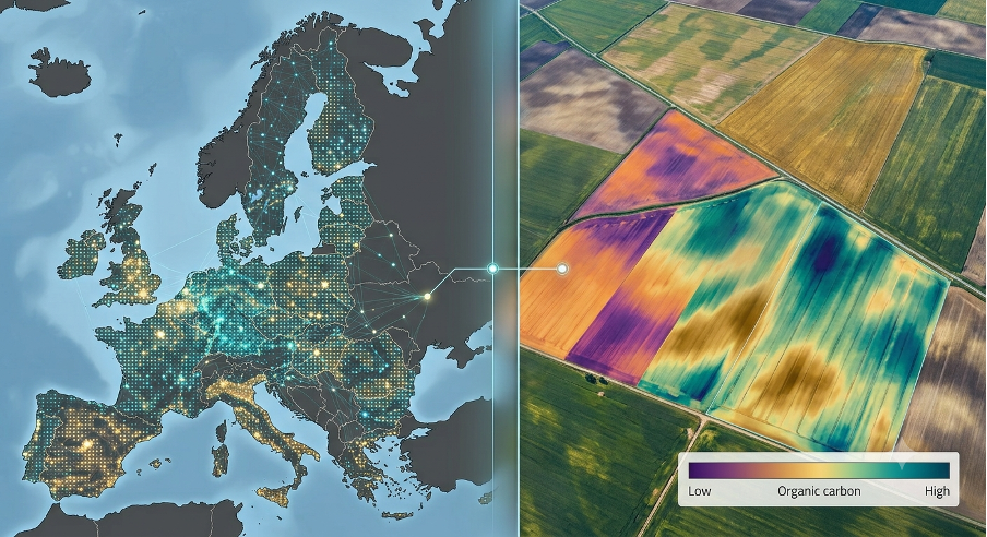
Our method rests on bringing together two complementary sources of information. The first is a large, ground-truth soil database. We build on a reference dataset of more than 7,000 real soil measurements collected from agricultural fields across Europe. Each point includes laboratory-measured values for key soil properties. This is the "truth" our models learn from — a broad, geographically diverse foundation that spans many soil types, elevations, climates, and crop types. The second is the AlphaEarth dataset. For every location, we pair those laboratory measurements with features from AlphaEarth, an analysis-ready dataset that compresses a full year of satellite imagery and environmental data into a compact numerical "fingerprint" for each pixel on the ground. Instead of working with raw images from a single date, AlphaEarth summarizes how each piece of land looks and behaves over an entire year into a 64-dimensional embedding. This captures patterns in vegetation, surface conditions, and seasonal dynamics that correlate with what lies in the soil below. By aligning each of the 7,000+ soil samples with its corresponding AlphaEarth fingerprint, we create a training dataset that links what we can see from space to what has been measured in the lab.
From fingerprints to soil properties
Using this combined dataset, we train machine-learning models to predict soil properties directly from the AlphaEarth fingerprint. We target a range of agronomically important properties, including:
- pH (soil acidity)
- Organic carbon (a proxy for organic matter and soil health)
- Carbonate / lime content (CaCO₃)
- Nitrogen, phosphorus, and potassium (the primary nutrients)
At the core of our modeling is the Random Forest algorithm — an ensemble method that combines many decision trees to capture the complex, non-linear relationships between the AlphaEarth fingerprint and the soil property being predicted. Random Forest is well suited to this task: it handles high-dimensional, correlated features robustly, is resistant to overfitting, and provides a measure of which parts of the fingerprint matter most for each property.
Why this matters for farmers
If a soil property can be estimated reliably from satellite-derived fingerprints, it can map those fingerprints everywhere — not just where samples happened to be taken. That opens the door to a continuous picture of how pH, organic matter, lime, and nutrients vary across a field, rather than a few isolated points. In practice, this could support:
- Variable-rate management of lime and fertilizer, targeting inputs where they are actually needed.
- Faster, lower-cost assessment of new or unfamiliar fields.
- Monitoring change over time, since the underlying satellite data is updated season after season.
Where we are, and where we are going
This new feature is still under development. The current work focuses on building and validating the models on Europe-wide reference data, and on understanding the accuracy that can realistically be achieved for each soil property. Some properties are inherently easier to infer from above-ground signals than others, and being transparent about those limits is part of doing the science properly. What excites us is the trajectory. Combining a uniquely large soil database with a powerful representation of the field like AlphaEarth is exactly the kind of unique capability we set out to build at Xsupra — practical tools that save time, reduce costs, and help our customers make better decisions on the ground. We will continue to share results as this work matures. If you would like to follow the development or discuss what it could mean for your operation, get in touch with the Xsupra team.
Try it now
See how Xsupra works on your fields. Free to get started.
Free to get started, no credit card required